
Geospatial Revolution: GIS Vocabulary
(Interactive)

Geospatial Revolution: Your Next Job
(Interactive)
 Download and Share
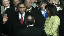
Data provided by geographic information systems (GIS) has opened doors to analyzing information across many disciplines. Uses for GIS technologies are wide and varied. A newer use of GIS data is to target potential voters during political campaigns.
Campaign managers and candidates alike are becoming savvy to the invaluable information that GIS can provide regarding their constituents. They are able to target groups quickly using public information such as U.S. Census data and voting records. The data is then compiled, merged and organized for the campaign. With the help of GIS technologies, data collection takes days instead of weeks or months to sort through the information. This saves both time and money—two valuable assets to political campaigns.
The 2008 Obama presidential campaign was a very good example of the value GIS data can provide to a political campaign. The campaign held an intensive voter registration drive in the six months leading up to the November election called Vote for Change. Campaign volunteers visited communities targeted by GIS information, and helped individuals register to vote. It is widely recognized that this strategic use of GIS data was a contributing factor to President Obama’s election.
However, some experts argue that while GIS data has been effective in voter registration, it has not been used to its full potential when buying media advertisements. One political researcher points to “time geography,” the notion that humans spend parts of the day in different places. As people travel on their daily routes, they may see a billboard that they might not see at home because that area is not targeted by the campaign. Experts suggest that the analysis of GIS data informed by "time geography" should be considered when campaigns make media buys.
Information provided by GIS technologies can be useful to the general public during political campaigns. News agencies now use GIS data during their campaign coverage to inform voters about trends in different geographic areas. This helps voters visualize the electoral process. On election night, news agencies also use GIS data to predict which candidate will claim the election and the impact that certain geographic areas will have on the outcome. However, media outlets should avoid overloading viewers with too much information delivered at a rate they are unable to absorb.
As in countless other areas, GIS technologies have changed the landscape of the political campaign. They provide a more informed candidate and a more informed voter, which can help to strengthen the democratic process.
To learn more about the history of geography, check out a video resource that traces the origin of maps to clay tablets in Babylonian times Geospatial Revolution: History of Geography.
To learn more about why you might want to study geography, check out a video resource that illustrates how maps can help you protect yourself and your house from an emergency, like raging wildfires Geospatial Revolution: Why Study GIS?.
To learn more about why geography is important, check out a video resource that explains how GIS helps us to understand how the earth works, climate change, and what new occupations have been sparked by emerging geospatial technologies Geospatial Revolution: Importance of Geography.
To learn more about the history of GIS, check out a video resource that traces the development of GIS from centuries of mapmaking to 21st century computer-based technology Geospatial Revolution: History of GIS.
To learn more about vocabulary that has developed with the growth of GIS, check out this interactive with relevant videos and embedded assessments of your understanding Geospatial Revolution: GIS Vocabulary.
To consider the expanded roles and responsibilities of citizens and government In the digital age, check out a video resources that profiles a city using technology, especially geospatial applications, in a variety of operations. Geospatial Revolution: Portland, an Interactive City.
To consider how GIS technology is helping address the lack of easy access to fresh food in high poverty neighborhoods, check out a video resource that profiles Philadelphia's use of geospatial applications. Geospatial Revolution: Food Deserts.
To consider how technology is rapidly changing the nature of jobs and careers in ways that will affect your opportunities, check out an interactive resource that profiles several job requirements at UPS. Geospatial Revolution: Your Next Job.
To learn more about how GIS is used to monitor areas of conflict, check out a video resource that shows how the US military uses GIS to protect soldiers in combat Geospatial Revolution: GIS to Monitor Areas of Conflict.
 Loading Standards


 Print Background Essay