Teachers' Domain - Digital Media for the Classroom and Professional Development
User: Preview


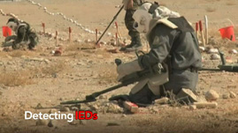
GIS is widely used for monitoring and observation of every kind of geographical and human feature, especially toward the causes of protection and management. A variety of institutions worldwide employ it for an even greater variety of applications, ranging from rainforest protection to disaster relief. In this video from Episode 3 of Penn State Public Broadcasting’s Geospatial Revolution we see the U.S. military in warzones using geospatial technology to help soldiers map the terrain, including identify probable locations of Improvised Explosive Devices (IED). Soldiers use GIS to orient themselves to the location of their missions, to think like the enemy, make precise attacks and reduce collateral damage.
Observing the environment has been an important activity for communities, nations, farmers, scientists and really anyone who is aware of how the social, political and ecological environment impacts one’s life. Before the invention of satellite technology such observations were manual jobs limited by the reach of human eyes, transportation, telescopes and time. For instance, predicting weather patterns or foreign invasions was possible only a few days or weeks in advance of the event, robbing those affected of crucial decision making abilities. The first episode of Penn State Public Broadcasting’s Geospatial Revolution showed how the process of monitoring and identification of terrain features changed over a period of time starting in the early 20th century. The third episode of this series shows the ways in which the U.S. military today is using GIS is to monitor its war zones, but the applications truly range far and wide.
Geospatial technologies have been used to monitor the man-made as well as natural environment for several decades now. GIS has helped the Manchester Airport in the UK manage its burgeoning growth in a sustainable manner. Brazil’s rainforest and the vast stretches of rainforest between Mexico and Guatemala have been preserved thanks to visual images of deforestation provided by geospatial technologies. Similarly, mining companies in several parts of the United States use GIS to monitor their environmental impact and governments all over the world use it to monitor large-scale environmental disasters and relief. The military was one of the early adopters of such technologies. This video from Episode 3 of Geospatial Revolution highlights the way in which the US military identifies Improvised Explosive Devices (IEDs) in a given location using satellite imagery. Such technology has been supported by mathematical models, which predict the locations and timings of IED placement and explosions, potentially saving the lives of soldiers as well as civilians. For instance, researchers from the universities of Maryland and Torino, Italy recently developed software called Spatio-Cultural Abductive Reasoning Engine or SCARE. This software helps analysts combine military intelligence and knowledge with mathematical techniques to accurately identify probable IED locations. The predictive and preventative nature of this software can have far reaching consequences on the peace and security of a region.
The geospatial revolution has made it possible to watch the unfolding changes on the surface of the earth, whether a road or a forest, an ocean or a nuclear enrichment facility. It provides crucial information about the natural planet and human activity- information that can be used to reverse or prepare for those changes in ways that better protect our world.
To learn more about the history of geography, check out a video resource that traces the origin of maps to clay tablets in Babylonian times Geospatial Revolution: History of Geography.
To learn more about political geography, check out a video resource about maps that revealed potential voters during the 2008 presidential campaign Geospatial Revolution: Political Aspects.
To learn more about why geography is important, check out a video resource that explains how GIS helps us to understand how the earth works, climate change, and what new occupations have been sparked by emerging geospatial technologies Geospatial Revolution: Importance of Geography.
To learn more about why you might want to study geography, check out a video resource that illustrates how maps can help you protect yourself and your house from an emergency, like raging wildfires Geospatial Revolution: Why Study GIS?.
To learn more about vocabulary that has developed with the growth of GIS, check out this interactive with relevant videos and embedded assessments of your understanding Geospatial Revolution: GIS Vocabulary.
To consider the expanded roles and responsibilities of citizens and government In the digital age, check out a video resources that profiles a city using technology, especially geospatial applications, in a variety of operations. Geospatial Revolution: Portland, an Interactive City.
To consider how technology is rapidly changing the nature of jobs and careers in ways that will affect your opportunities, check out an interactive resource that profiles several job requirements at UPS. Geospatial Revolution: Your Next Job.
To learn more about the history of GIS, check out a video resource that traces the development of GIS from centuries of mapmaking to 21st century computer-based technology Geospatial Revolution: History of GIS.
To learn more about food deserts, or a lack of easy access to nutritious food, check out a video resource that shows how geospatial technology can help change this reality Geospatial Revolution: Food Deserts.
. Loading Standards