
Geospatial Revolution: GIS Vocabulary
(Interactive)

Geospatial Revolution: Your Next Job
(Interactive)
Kibera, a poor community in Nairobi, was a blank spot on the map until recently. This video from Penn State Public Broadcasting’s Geospatial Revolution shows how geospatial technology enabled residents to map important resources to help their community.
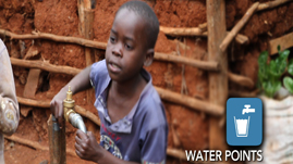
Residents from Kibera went out into the community with GPS devices and located areas with community resources: houses, businesses, schools, health clinics, movie theaters, mills for grinding corn, restaurants, and bars, as well as areas that needed resources.
In one example, young girls helped map areas where they were often raped, and as a result, the community now polices those areas.
 Download and Share
When asked, “Why do we have maps?” The majority of the population would probably respond, “to get directions for a particular place.” And this was the response the organizers got when they started to talk to the Kibera residents about mapping their community. “Why do we need a map? We know where everything is.”
Thus, the education of mapping and the larger reason for maps was begun. Maps always exist for a reason. Many maps were created for commercial/trade (think sea ports and frontier forts with dry goods stores), governmental (census, tax purposes, boundaries of countries), or military reasons (where weapon stashes or troops are located). It takes a lot of investment of time and energy to create a map. Traditionally, the amount of effort and resources required was only available to governments and corporations. However, modern technology has made mapping available to anyone. With the greater availability of maps and tagging resources, maps have become increasingly important. Instead of simply providing directions, maps can help locate important resources in a community or where resources are needed but non-existent. Thus maps have become more than a sum of their parts. They help tell the story of a community.
However, even today in this century, there are many blank places on maps around the world. Some maps have notable gaps – not because no one lives there but for a variety of reasons the residents never had the opportunity to contribute the story of their place.
As the video depicts, Kibera was one such place. On the map of Nairobi, it simply didn’t exist. Kibera is the Nubian word for forest. More than half a century ago, there was a forest where the slum of Kibera now exists. But as the population grew and the forest dwindled, the maps never changed to reflect the new purpose of the space.
The houses within Kibera are very small. They're usually made of mud, corrugated iron and so forth. They are located one right after another. But there are also businesses, schools, health clinics, movie theaters, mills for grinding corn, restaurants – lots of restaurants and bars – so there's basically a fully functioning city in the midst of the city which is completely informal. It’s also very poor. People live on a day-to-day income. They survive from odd jobs they can get.
To the residents of Kibera, their maps have become important. They can now make decisions about their own community. And with today’s technology, they can continually update their maps as Kibera grows and changes.
To learn more about the history of geography, check out a video resource that traces the origin of maps to clay tablets in Babylonian times Geospatial Revolution: History of Geography.
To learn more about political geography, check out a video resource about maps that revealed potential voters during the 2008 presidential campaign Geospatial Revolution: Political Aspects.
To learn more about why geography is important, check out a video resource that explains how GIS helps us to understand how the earth works, climate change, and what new occupations have been sparked by emerging geospatial technologies Geospatial Revolution: Importance of Geography.
To learn more about why you might want to study geography, check out a video resource that illustrates how maps can help you protect yourself and your house from an emergency, like raging wildfires Geospatial Revolution: Why Study GIS?.
To learn more about vocabulary that has developed with the growth of GIS, check out this interactive with relevant videos and embedded assessments of your understanding Geospatial Revolution: GIS Vocabulary.
To consider the expanded roles and responsibilities of citizens and government In the digital age, check out a video resources that profiles a city using technology, especially geospatial applications, in a variety of operations. Geospatial Revolution: Portland, an Interactive City.
To consider how technology is rapidly changing the nature of jobs and careers in ways that will affect your opportunities, check out an interactive resource that profiles several job requirements at UPS. Geospatial Revolution: Your Next Job.
To learn more about the history of GIS, check out a video resource that traces the development of GIS from centuries of mapmaking to 21st century computer-based technology Geospatial Revolution: History of GIS.
To learn more about how GIS is used to monitor areas of conflict, check out a video resource that shows how the US military uses GIS to protect soldiers in combat Geospatial Revolution: GIS to Monitor Areas of Conflict.
To consider how GIS technology is helping address the lack of easy access to fresh food in high poverty neighborhoods, check out a video resource that profiles Philadelphia's use of geospatial applications. Geospatial Revolution: Food Deserts.
 Loading Standards


 Print Background Essay