
Geospatial Revolution: GIS Vocabulary
(Interactive)

Geospatial Revolution: Your Next Job
(Interactive)
 Download and Share
Through time maps have appealed to individuals in every culture, in every country, as a way to represent spatial concepts large and small. Some historians argue that maps predate the written word.
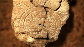
The earliest known maps were clay tablets during Babylonian times. Around the time of Aristotle ancient Greek philosophers accepted the concept of a spherical earth. Greek and Roman cartography culminated in an atlas created by Ptolemy, an influential Greek astronomer and geographer, around 150 CE. Ptolemy’s earth-centered map influenced Islamic and European cartographers until the 16th century when Copernicus proposed a sun-centered view.
Medieval maps in Europe often reflected religious views, with Jerusalem at the center and the east positioned at the top of the map. A common type was a T-O map from the Latin orbis terrarum or circle of the lands. It took the form of the letter T inside of an O. In the 12th century, maps began to add information from the Vikings’ explorations of the North Atlantic. Islamic cartographers drew more practical and realistic maps that included the Mediterranean. Few hand-drawn and illuminated maps were distributed because they were so labor intensive to produce.
Printing allowed a much wider distribution of maps. Beginning in the 15th century, Renaissance maps were printed on carved wooden blocks. By the 16th century printers began using engraved copper plates to generate maps, a practice that lasted until the development of photographic techniques. Explorers from the 15th and 16th century brought back information about the land and seascape, and as a result, cartography leaped forward with the production of navigation charts, new map projections and globes. The voyage of Columbus and other explorers to the New World in the 16th century brought the first whole world maps.
The scientific method, with its attention to facts, increased the accuracy of maps in the 16th, 17th and 18th century. Post World War I mapmaking improved with the use of aerial photography. Previously maps were based solely on observations from the ground. In addition to ground observations and aerial photography, today’s mapmakers depend upon remote sensing as a source of information.
A modern map user can select from spatial databases to generate a customized view with layers of information designed for a particular purpose. The shift from printed to electronic maps began in the 60s as computers combined software, hardware and data into Geographic Information Systems (GIS). These new GIS systems empower a student to create new knowledge as he or she gathers, analyzes, and displays data in an appropriate format to persuade or inform others.
To learn more about the history of GIS, check out a video resource that traces the development of GIS from centuries of mapmaking to 21st century computer-based technology Geospatial Revolution: History of GIS.
To learn more about political geography, check out a video resource about maps that revealed potential voters during the 2008 presidential campaign Geospatial Revolution: Political Aspects.
To learn more about why geography is important, check out a video resource that explains how GIS helps us to understand how the earth works, climate change, and what new occupations have been sparked by emerging geospatial technologies Geospatial Revolution: Importance of Geography.
To learn more about why you might want to study geography, check out a video resource that illustrates how maps can help you protect yourself and your house from an emergency, like raging wildfires Geospatial Revolution: Why Study GIS?.
To learn more about vocabulary that has developed with the growth of GIS, check out this interactive with relevant videos and embedded assessments of your understanding Geospatial Revolution: GIS Vocabulary.
To consider the expanded roles and responsibilities of citizens and government In the digital age, check out a video resources that profiles a city using technology, especially geospatial applications, in a variety of operations. Geospatial Revolution: Portland, an Interactive City.
To consider how GIS technology is helping address the lack of easy access to fresh food in high poverty neighborhoods, check out a video resource that profiles Philadelphia's use of geospatial applications. Geospatial Revolution: Food Deserts.
To consider how technology is rapidly changing the nature of jobs and careers in ways that will affect your opportunities, check out an interactive resource that profiles several job requirements at UPS. Geospatial Revolution: Your Next Job.
To learn more about how GIS is used to monitor areas of conflict, check out a video resource that shows how the US military uses GIS to protect soldiers in combat Geospatial Revolution: GIS to Monitor Areas of Conflict.
 Loading Standards


 Print Background Essay