Teachers' Domain - Digital Media for the Classroom and Professional Development
User: Preview


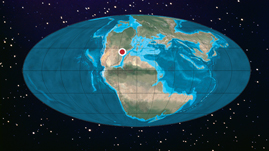
This interactive adapted from Kentucky’s Natural Heritage: An Illustrated Guide to Biodiversity demonstrates the location of Kentucky through different geological eras of time. As students follow Kentucky through the Cambrian, Silurian, Permian, Jurassic, Cretaceous, and Neogene Periods, they can read about examples of species and terrain you might see during each period.
The planet Earth has not always looked the way it does today, not just the people and technology, but the actual, physical planet. Over the billions of years since Earth was created, landmasses have moved, come together as one, broken into pieces, and finally split into the contents and islands we are familiar with today. All of this happened because the continents drift, or move.
This “drifting” is caused by something known as plate tectonics. On the ocean floor about halfway between the continents are ridges that resemble underwater mountain ranges. In other areas there are deep trenches, some measuring thousands of feet deep. Scientists believe that these ridges are new crust being formed as hot magma pushes it’s way out of the center of the Earth. As the seafloor spreads out away from the magma, the continents are moved across the ocean.
Over 490 million years ago, Kentucky was part of an island much further south than it is today. Throughout time, continental drift has carried it to many interesting locations before it settled here. And, thanks to continental drift, this is just another stop on its journey!
Working in groups or individually, have students use the interactive to plot the different locations of Kentucky then make a logical prediction about where Kentucky might be in another 50 million years. Have them support their answer with a thoroughly written explanation.
 Loading Standards