Teachers' Domain - Digital Media for the Classroom and Professional Development
User: Preview

Source: UNEP/GRID-Arendal


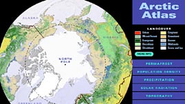
In this interactive atlas adapted from UNEP/GRID-Arendal, investigate variations in the Arctic environment. A customizable map presents a polar view of all areas north of 50° N and displays data about six different themes: landcover types, permafrost, population density, precipitation, solar radiation, and topography. Examine the themes in more detail by zooming in to see the featured regions of Alaska, Canada, Europe, Greenland, Iceland, and Siberia.
Some people define the Arctic as the area north of the Arctic Circle (67° N, the latitude above which areas experience polar day and polar night—when the Sun appears above or below the horizon, respectively, for more than 24 hours); others define the Arctic as the region north of the treeline (the border beyond which trees are unable to grow) or as the region where the average temperature for the warmest month is below 10°C (which generally corresponds to the area north of the treeline). Regardless of the particular definition, "the Arctic" evokes images of an icy and snow-covered landscape.
However, the Arctic is not simply snow and ice: the region encompasses a large area and exhibits great environmental variability. The Arctic consists of an ocean surrounded by land. While the central Arctic is covered by sea ice year-round and is rather lifeless, other regions are not so plain and barren. These regions include ice, ocean, land, mountains, and tundra vegetation (such as grasses, mosses, lichens, and shrubs), which is more abundant at the lower latitudes and in more hospitable climates.
Solar radiation plays a major role in determining Arctic climate. Incoming sunlight is less intense at the poles because of Earth's shape and position in relation to the Sun. In addition, snow and ice have high "albedos." Surfaces with a high albedo do not absorb as much solar energy; instead, they reflect a greater proportion of it back into space. Land, water, and even wet snow have lower albedos and absorb more energy. Thus, because the lower latitudes of the Arctic absorb more solar radiation, they are generally warmer and support more plant growth. Furthermore, the absorption of solar radiation also varies with topography. For instance, the south-facing side of a slope receives more solar radiation than other areas. Topography becomes an increasingly important climatic factor at higher latitudes; because of the low angle of incidence of solar radiation, even slight differences in topography (such as a hill) can cause variations in local climate due to shading.
The ocean also influences Arctic climate. In particular, warm water currents that bring heat from lower latitudes keep some areas of the Arctic warmer than others. For example, winters are not as cold in northern Norway, located near a northward flowing warm current, as they are in a location at the same latitude in Greenland. In addition, because warmer temperatures increase evaporation and the amount of moisture in the air, the warm currents also lead to increased precipitation. Water also has a higher heat capacity than land; in other words, water retains heat longer and cools more slowly than land. As a result, locations near the ocean experience smaller temperature variations and have a more moderate climate than inland areas. People who live in the Arctic are generally located at the lower latitudes and along the coast, where not only is the climate less extreme, but they also have easier access to resources necessary for survival, such as fish, seals, whales, and plants.
 Loading Standards
 Teachers' Domain is proud to be a Pathways portal to the National Science Digital Library.
