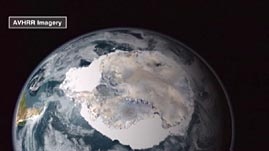
Source: NASA/Goddard Space Flight Center Scientific Visualization Studio
National K -12 Subject:
Lesson Plans Using this Resource:
This video segment adapted from NASA uses satellite imagery to provide an overview of the cryosphere in the Antarctic. Learn about Antarctic features such as clouds, glaciers, ice streams, ice shelves, and icebergs. In addition, explore how rising temperatures affect the region, for example by increasing the number of meltwater ponds, which can lead to the weakening and collapse of ice shelves. Finally, see seasonal changes in sea ice and learn about their influence on ocean circulation.
 Download, Share, and Remix
Earth's polar regions are part of the cryosphere—the frozen areas of Earth's surface, including snow, glaciers, ice sheets, ice shelves, icebergs, sea ice, and permafrost (land that is below 0°C for two or more years). Scientists are interested in studying the cryosphere because it plays an important role in regulating Earth's climate system. For example, sea ice acts as an insulating barrier and reduces the transfer of moisture and heat from the ocean to the air, which affects atmospheric circulation. In addition, freezing and melting of sea ice affect the salinity of the water and influence ocean circulation patterns.
Snow and ice are also highly reflective and thus strongly influence Earth's radiation budget. Earth's average overall albedo (the percentage of sunlight that is reflected from the surface) is about 30 percent; in other words, Earth absorbs about 70 percent of incoming solar radiation. However, because snow and ice are much more reflective than water and land (the albedo of fresh snow is about 90 percent), they decrease the amount of energy absorbed by Earth and have a cooling effect. As a result, the amount of surface area covered by snow and ice has a significant impact on Earth's climate. Changes such as a decrease in the size of the cryosphere caused by melting can trigger a positive feedback loop and accelerate climate change. Warmer temperatures melt snow and ice, which decreases Earth's albedo, which in turn causes further warming and more melting.
Satellites play a vital role in helping scientists study the cryosphere because they gather data in remote areas where it is difficult to gather direct, hands-on measurements. Prior to satellite technology, polar scientists could only collect data in small areas and at limited time intervals. However, from their vantage point above Earth's surface, satellites can make large-scale observations of the planet at regular intervals. For instance, microwave sensors and radar systems onboard satellites can easily map Antarctica's ice cover throughout the year despite its remote location, extreme temperatures, and frequent cloud cover and darkness.
Instruments onboard satellites make measurements by detecting and recording electromagnetic radiation in a range of wavelengths, such as visible, infrared, and microwave. After the data is processed, false colors are assigned to the data to create images that help scientists visualize the information. With the wealth of information gathered by satellites, scientists hope to gain a better understanding of the polar regions and the potential consequences of changes to the cryosphere.
 Loading Standards


 Print Background Essay