Source: NatureScene: “Death Valley”
National K -12 Subject:
Take a walk through Death Valley as host Jim Welch and naturalist Rudy Mancke discuss the glacial history, tectonic forces, and weathering and erosion that have shaped Death Valley. They point out some geologic features that characterize the area including fault block mountains, alluvial fans, and craters.
 Download, Share, and Remix
Death Valley is a place of extremes. Established as a National Park in 1933, Death Valley is the largest national park in the continental United States, although the valley itself is only 100 miles long. Located in eastern California, Death Valley partially occupies the Mojave Desert and is the hottest place in the western hemisphere, with summer daytime temperatures exceeding 120 degrees. Death Valley also features the lowest point in the continental United States, Badwater Basin, at 282 feet below sea level. A testimony to the regions' violent tectonic past, Badwater Basin is only 100 miles away from the highest point in the continental United States, Mount Whitney, at 14,494 feet.
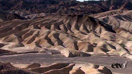
The mountain ranges in Death Valley are characterized as fault block mountain ranges. This phenomenon occurs when blocks of rock are either squeezed above Earth's crust along parallel faults or are loosened and sink when crust separates at a fault. In Death Valley, both forces are acting simultaneously, causing mountains to be uplifted while the valley floor is dropping. The formation of the fault block mountain ranges in Death Valley and in the Sierra Nevadas began less than four million years ago.
Death Valley is located in the geographic region known as the Basin and Range province, which stretches from Utah and Nevada south to Mexico. A topographic map of the area shows that its mountain ranges run parallel, as do the basins in-between. The parallel orientation resulted from the widespread collision between the Pacific and North American plates, beginning about 25 to 30 million years ago. Following this upheaval, subsequent collisions between the Pacific and Farralon plates caused an unexplained reversal in plate movement. Some evidence suggests that in Death Valley, the Panamint, Black, and Cottonwood mountains were at one time stacked on top of one another. Presently, the Pacific and North American plates continue to separate from one another at an average rate of several centimeters each year, as the Pacific plate inches in a northwesterly direction.
The same magma below Earth's crust that can move a fault block can heat groundwater enough to cause steam explosions, as seen in the crater at Ubehebe, which formed about 4,000 years ago. Besides a small pond at the base of Badwater Basin, groundwater may be the only water readily found in Death Valley. In its arid climate, average rainfall measures only half an inch to perhaps a few inches of rain each year. It is difficult to imagine that the area used to be covered by water and surrounded by verdant forests. During the Pleistocene epoch, between 10,000 and 1.6 million years ago, Lake Manly filled Death Valley to 600 feet. Eventually the water evaporated, precipitating out the salt pan that is now the crust of the valley floor.
Geologically speaking, Death Valley is still very much alive. The area is continuously changing both because of creeping tectonic forces as well as weathering and erosion. Alluvial fans indicate where deposits of gravel, sand, silt, and clay have been carried by wind and rain from the drainages between slopes, then swept across those slopes in a fan-like fashion and piled on the valley floor down below. In some instances, as much as 10,000 feet of sediment can accumulate to cover a mountainside. When this material calcifies and is uplifted, the sedimentary composite material, called fanglomerate, is then exposed.
To learn more about Earth's surface processes, see The Grand Canyon: How It Formed, Geology of North Dakota Badlands, The Grand Canyon: Ancient Mountains, and Erosion and Weathering.
To understand the forces behind the tectonic activity in the U.S. west, check out Plate Tectonics: Lake Mead, Nevada and Plate Tectonics: The Scientist Behind the Theory.
To find out more about mountains and the rock cycle, check out The Grand Canyon: Ancient Mountains, The Grand Canyon: Its Youngest Rocks, Mountain Maker, Earth Shaker, and Rock Cycle Animation.
 Loading Standards


 Print Background Essay