Source: NatureScene: “Theodore Roosevelt National Park”
National K -12 Subject:
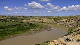
In this video segment from NatureScene, host Jim Welch and naturalist Rudy Mancke stroll through the North Dakota badlands. Join them as they discuss the effects of wind and rain erosion. See how the Little Missouri River and its tributaries have carved the landscape. Also, learn about the formation of layered bluffs and hillsides and what they can reveal about the geologic history in the area.
 Download, Share, and Remix
Among the grasslands, canyons, and hillsides of the Northern Great Plains are layered rock formations referred to as "badlands," a seemingly endless undulating landscape of fragmented hills and valleys, fashioned from volcanic activity, glacial action, and erosion. These landforms occur throughout the world, and can be found in North America in places like Alberta, Canada, as well as California, Arizona, Nebraska, Kansas, Colorado, Wyoming, and the Dakotas.
The Dakotas badlands region has one of the highest known rates of erosion. Stream erosion, as well as wind and rain, have carved the plains into strangely-shaped buttes and pinnacles, leaving unique structures like hoodoos and cap rocks. These formations were created through the process of differential weathering, which wears away layers of softer material more quickly, leaving behind the more resistant strata. The stratified bluffs of the badlands are often separated by streams and tributaries of nearby rivers like the Little Missouri, which contribute to water erosion in the area. Torrential downpours cause short-lived but deep, rapidly flowing flood waters in the otherwise dry channels or gullies that cut deep into slopes. Scarce vegetation, a factor of the severe climate, leaves few roots or protective cover to help hold the hillsides in place.
Fierce winds also sculpt the topography, revealing colorful composite layers that include volcanic ash, shale, limestone, sandstone, mudstone, and lignite. Over time, each layer has solidified into rock. Together, they reveal what has happened to the landscape over several millions of years.
For half a billion years, between roughly 570 and 80 million years ago, the badlands were covered by ocean, beginning with the Cambrian Sea. As the land rose, water drained away, leaving streams to carry sand and gravel from the west, creating a wetland plain. Between 65 and 80 million years ago, the Rockies were forming to the west, and the plain was eventually covered in volcanic ash, carried by wind and water.
Measuring as thick as 2,000 feet, the oldest and deepest layer in the badlands consists of shale, a sedimentary mudstone from the uplifted ocean floor. Atop the shale, a layer of white volcanic ash contains fossils dating back 35 million years. These are remains of animals that lived in the area during the Oligocene period, known as the "Golden Age of Mammals." Many of these creatures died out with global cooling, about 600,000 years ago, as climate changed and glaciers carved through seabed sediments.
Remnants of a continuous grassy plain that once blanketed the region are now found in patches on the tops of some of the rock formations in the badlands. Scientists predict that the badlands will return to the state of a flat prairie within the next half-million years due to the very agents of erosion that continue to shape them.
To learn more about Earth's surface processes, see The Grand Canyon: How It Formed, Geology of Death Valley, The Grand Canyon: Ancient Mountains, and Erosion and Weathering.
To find out more about mountains and the rock cycle, check out The Grand Canyon: Ancient Mountains, The Grand Canyon: Its Youngest Rocks, Mountain Maker, Earth Shaker, and Rock Cycle Animation.
To learn more about deserts and climate change, check out Deserts and Natural Climate Change in Djibouti, Africa.
 Loading Standards


 Print Background Essay