Teachers' Domain - Digital Media for the Classroom and Professional Development
User: Preview

Source: The New Media Studio.
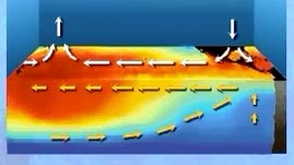
Interactions between Earth's atmosphere and oceans drive weather and climate patterns. Although these interactions and patterns are complex, they are also predictable. This animation from The New Media Studio explains precipitation patterns by illustrating how differences in ocean surface temperatures create wind, and how wind patterns can in turn affect ocean surface temperatures.
The Sun's energy is distributed unevenly across Earth's surface. Areas near our planet's equator absorb far more heat energy than areas near the poles. This uneven distribution of heat creates instability in Earth's atmosphere and oceans, and instability leads to movement of air and water.
Air in the atmosphere is warmed by heat radiating from Earth's surface. The warmer the surface is, the warmer the air above it becomes. Because warm air is less dense than cold air, it tends to expand and rise, which lowers air pressure near the surface. Thus, regions of low air pressure generally form over warm water and land, while high-pressure regions form over cool surfaces. Such pressure differences create circular patterns of air called convection currents. In a convection current, warmer, low-pressure air rises and cooler, high-pressure air rushes in to fill the void. As the warm air rises, it loses heat in the upper atmosphere, cools, and sinks back toward Earth's surface, completing the circuit.
The movement of air from high to low pressure in convection currents is responsible for most winds that blow across Earth's surface. The northern and southern hemispheres each have three zones in which winds blow predictably from east to west or west to east. On either side of the equator are zones dominated by the northeast and southeast trade winds, which blow strongly from east to west, and drive ocean currents in the same direction. The constant blowing of these strong winds pushes the warm surface water westward and causes a swell of warm water to build up in the western Pacific. In most years, the height of the sea surface near Indonesia is about 0.5 meters (1.6 feet) higher than off the coast of Ecuador, and the water temperature is warmer by about 8 degrees Celsius (14 degrees Fahrenheit). On the east side of the ocean, cold water rises up from great depths to replace the water that was pushed westward.
The interaction between global surface winds and ocean currents creates predictable climate patterns. For example, the heat carried westward by the warm ocean current causes powerful thunderstorms in northeastern Australia and eastern Indonesia. In contrast, the cold ocean surface on the east side of the Pacific gives rise to high pressure areas and low precipitation for much of the west coast of South America.
About every three to four years, climate patterns in and around the Pacific Ocean change dramatically. The trade winds slacken and warm water that had been pushed to the west side of the Pacific is allowed to return eastward. This pattern, known as El Niño, typically causes droughts in Australia and Indonesia and damaging thunderstorms and floods in parts of South America and southern North America.
 Loading Standards
 Teachers' Domain is proud to be a Pathways portal to the National Science Digital Library.
