
Source: NOVA: "Volcano Above the Clouds"
Mountains can be awe-inspiring both for the vistas they provide and for the weather events and long-term climate systems they support. This interactive activity from NOVA Online illustrates how a moisture-laden air mass interacts with a mountain slope to produce characteristic patterns of precipitation over the mountain and surrounding areas.
Mountain Weather (HTML version) (Interactive)
On average, the tropics receive more solar radiation annually than zones located at higher latitudes. But solar radiation is only one of several variables that determine the mean annual temperature of a given region. For example, Quito, Ecuador is on average 10°C (18°F) cooler than Miami, Florida, despite sitting much closer to the equator. The main reason for this discrepancy is elevation. While Quito sits 2,800 meters (9,200 feet) above sea level in the Andes Mountains, Miami is a mere 3 meters (9 feet) above sea level.
Ecuador is located on the west coast of South America. This means that the Pacific Ocean lies to the west and the Amazon rainforest lies to the east, allowing the prevailing winds to pick up moisture from whichever direction they are blowing. These moisture-laden air masses are then driven upward by the slopes of the Ecuadorian Andes.
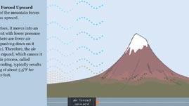
A rising air mass experiences decreasing atmospheric pressure the higher in altitude it goes. This decrease in pressure allows the air mass to expand, which in turn causes it to cool. On average, air temperature decreases 10°C for every 1,000-meter (18°F for every 3,280-foot) increase in altitude. This cooling also results in precipitation. If an air mass continues to rise, it eventually cools to its condensation temperature and forms clouds. When water droplets become large enough, they fall to Earth as precipitation. This example demonstrates how topography, moisture sources, and air masses interact with solar radiation to create local climate.
 Loading Standards


 Print Background Essay