Teachers' Domain - Digital Media for the Classroom and Professional Development
User: Preview

Source: Tom Whittaker and Steve Ackerman, University of Wisconsin-Madison
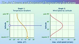
Many of us have seen beautiful, warm, autumn days turn unbearably cold in what seems like minutes. These dramatic temperature shifts are almost always ushered in by powerful winds. What may be less obvious is that temperature differences — or temperature gradients — between air masses is what actually causes wind. This interactive activity, adapted from the University of Wisconsin-Madison, puts you in control of the temperature gradient between two air masses and models the effects that changes in the temperature gradient have on wind speed.
Nearly all forms of weather, including Earth's most powerful winds, can be attributed to the fact that the Sun warms our planet unevenly. Because of the angle at which solar radiation strikes Earth's surface, regions near the equator are heated more intensely than those near the poles. In addition, the tilt of Earth's axis causes the amount of solar radiation received by the northern and southern hemispheres to change seasonally.
Some of the heat absorbed by Earth's surface is transferred to the atmosphere above. This results in areas of relatively warm air near the equator and areas of relatively cool air near the poles. Because atmospheric pressure varies with temperature, the uneven heating of Earth's surface also creates areas of high and low pressure. Since air generally moves from areas of high pressure to areas of low pressure, winds form where pressure differences exist. The greater the temperature and pressure gradient, the faster the wind will blow.
One of the most extreme temperature and pressure gradients is found at the polar front, where consistently cold polar air meets consistently warm sub-tropical air. This boundary of differences gives rise to the polar front jet stream, a high-speed band of wind traveling at up to 400 kilometers per hour (249 miles per hour) that encircles Earth at altitudes of 10-15 kilometers (6-9 miles). This stream of air tends to parallel the polar front. Sometimes it meanders wildly southward or northward, but in the northern hemisphere generally it moves from west to east. The average position of the jet stream in winter is over the southern U.S., while in summer it is near the U.S.-Canadian border. Since the north-south temperature gradients are greater during winter than during summer, the winds of the jet stream are faster in winter than in summer.
The polar front jet stream is instrumental in both creating and moving storms over the United States. The fastest winds within a jet stream, called jet streaks, can induce horizontal pressure differences at the surface that initiate mid-latitude storms. These storms track across the country guided by the jet stream.
 Loading Standards
 Teachers' Domain is proud to be a Pathways portal to the National Science Digital Library.
