Teachers' Domain - Digital Media for the Classroom and Professional Development
User: Preview

Source: University Corporation for Atmospheric Research, CGD, SCD
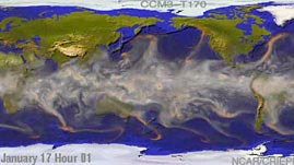
Water vapor plays an important role in the water cycle and in the distribution of heat around the planet. By observing the movement of water vapor, scientists can study global wind patterns and the development of cyclonic storms. In this simulation from the National Center for Atmospheric Research, water vapor circulates around Earth over the course of a year.
Water vapor -- the gaseous phase of water -- plays an important role in the water cycle and in regulating Earth's energy distribution. As oceans evaporate and plants transpire, liquid water from Earth's surface enters into the atmosphere as water vapor. When air cools, clouds form through water vapor condensation (forming liquid drops) or deposition (forming ice crystals); and clouds produce precipitation that returns liquid water back to Earth's surface. Water vapor is also a greenhouse gas, absorbing infrared radiation from the Earth and trapping heat in the atmosphere. Without the greenhouse effect, Earth would be a much colder and unlivable world. In addition, the movement of water vapor through the atmosphere aids in the distribution of heat around the planet. Water vapor is a critical component of Earth's atmosphere and, though it is invisible, it can be studied through the use of imaging that is sensitive to infrared wavelengths of about 6.5 to 7.4 micrometers in the electromagnetic spectrum. By assigning false colors to represent the infrared data, researchers are able to "see" water vapor in the atmosphere. In this simulation, water vapor is shown as white and precipitation is shown as orange. (Note: The white areas at the top and bottom of the simulation do not designate water vapor but instead represent the icy landscapes of the Artic and Antarctic.)
When looking at water vapor in Earth's atmosphere, it is interesting to note its distribution. Because warmer air requires more water vapor in order to become saturated (the point at which water vapor condenses), the greatest concentration of water vapor is in the warmest climates. Thus, the equatorial region, which receives the most solar radiation, contains the most water vapor. The effects of Earth's tilt, solar heating, and the rotation of Earth are responsible for the global wind patterns.
The intense low-pressure areas created in the tropics are responsible for the formation of tropical cyclones called hurricanes -- damaging storms with very strong rotating winds. Tropical cyclones are fueled by the energy from warm tropical waters. When liquid water changes to water vapor, heat energy is stored in the atmosphere. This latent heat is released when water vapor condenses into clouds and precipitation. Thus, cyclones are like heat transport machines, taking heat from the warm ocean waters and transferring it to the atmosphere. The circulation of water vapor in the atmosphere, along with ocean circulatory patterns, is critical to the distribution of heat around the world.
Earth's rotation influences wind direction. For example, the winds of a tropical cyclone in the northern hemisphere spin in a counterclockwise direction while a storm in the southern hemisphere spins clockwise. In the simulation, note the swirling patterns of water vapor near Central America during July and August and the tropical cyclone east of Madagascar in early October.
 Loading Standards
 Teachers' Domain is proud to be a Pathways portal to the National Science Digital Library.
