
Source: NOVA "Hunt for the Supertwister"
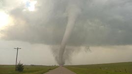
From an outsider's perspective, storm chasing might appear to involve hours and hours of boredom, accentuated by a few moments of unimaginable excitement — or terror — depending on one's love or fear of tornadoes. But to tornado researchers, the effort and expense they expend in search of a single tornado-producing storm reflect the importance of these events in terms of their impact on lives and property. This video segment adapted from NOVA follows some of the scientists who study these violent storms and highlights what they've learned about the storms and what they still want to know about the conditions that cause them.
 Download and Share
The capricious nature of tornadoes, coupled with the devastating damage they leave in their wake, has made their study a priority. Storm-chasing meteorologists spend months scanning the skies and reading output from weather radar systems in search of conditions that coincide with tornadoes. They are lucky if they see two per season. Still, their tireless effort has yielded our best understanding yet of the atmospheric conditions that give rise to the most violent of all weather events.
Meteorologists tie tornado formation directly to the most severe of all thunderstorms: supercells. These storms typically form in the United States when warm, moist air coming from the Gulf of Mexico encounters cool, dry air over the plains and Midwest. The warm air rises above the cooler air mass because it is less dense. As it does, moisture in the air condenses, releasing heat. The heat fuels the continued upward movement of the air column. Tornadic rotation can result from the rising air of the updraft interacting with the horizontal winds of the storm. These horizontal winds can move in different directions and at different speeds. Scientists also know that supercells drive intense downdrafts, and think that they may have a role in concentrating the rotating winds inside the storm and pulling them to the ground.
Doppler radar has been instrumental in helping researchers both to understand the role of downdrafts, and by extension, better predict where tornadoes might occur. This technology enables meteorologists to see the direction storms are moving, and also to read the intensity of precipitation and the wind speed inside them. It does this by emitting electromagnetic waves that bounce off water droplets inside a storm cloud. The radar receiver catches these waves on their return and a computer calculates the storm's wind speed and direction based on the change in frequency of the returning waves. Tornadoes show up on the Doppler radar images. Under certain conditions, such as those depicted in the video segment, the radar image shows hook-shaped wind patterns. This is a result of the downdraft coupled with the rotating wind of the storm.
Computer simulations have also allowed researchers to experiment with variables to better understand the atmospheric conditions that result in tornado formation. Computer modeling has revealed a number of clues, such as the possible role of tiny swirling winds near the ground that coincide with tornado formation.
As yet, however, researchers lack sufficient data to explain exactly how thunderstorms turn into tornadoes. The fact is, most storms don't. Perhaps understanding why will help scientists uncover the necessary trigger.
Learn in this NOVA classroom activity how to identify the best time of year to see possible tornado outbreaks.
 Loading Standards


 Print Background Essay