Source: NASA/Goddard Space Flight Center Scientific Visualization Studio
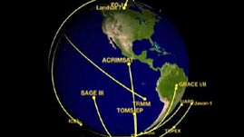
In recent years, there has been a push to better understand how Earth works as a system — how land, oceans, air, and life all interact. Satellites in orbit around Earth are a fast and efficient way of gathering remotely sensed data about the planet as a whole. This animation adapted from NASA shows the orbital paths of the satellites in the Earth Observing System.
 Download, Share, and Remix
The satellites in this animation are part of NASA's Earth Observing System (EOS) — a collection of satellites that work together to study Earth on a wide scale. The EOS is a coordinated fleet of satellites that provide long-term observations of the land, oceans, atmosphere, biosphere, and hydrologic cycle. The main goals of the EOS program are to create a multi-disciplinary understanding of how the Earth system is changing and to advance knowledge about the components of the Earth system.
Earth observing satellites can have two types of orbital paths. Geostationary satellites travel in the same direction and with the same speed as Earth's rotation, effectively staying above a particular location, continuously monitoring one view of Earth. Most weather satellites are geostationary, allowing for changes to be seen over time. Polar orbiting satellites travel quickly around Earth in a near-circle at lower orbits. These satellites observe a smaller swath of Earth as they orbit, but because Earth rotates below them, they travel over a different region with each orbit and eventually observe the entire planet. Most of the EOS satellites have these polar orbits, which offer closer views and complete coverage of the planet.
The view of Earth from orbit allows for broad-scale observations that could not be taken from the ground. By detecting electromagnetic radiation with onboard sensors and instruments, satellites gather data about the entire global system. Each of the satellites is specially designed for particular purposes, but their findings complement each other. For example, Aura, launched in 2004, studies the atmosphere with several different instruments using microwaves, visible light, and ultraviolet light (different types of radiation reveal different information) and builds on earlier research done by the satellite UARS (Upper Atmosphere Research Satellite) launched in 1991. Aura flies in formation with the satellites Aqua, CloudSat, CALIPSO, and OCO. This group of satellites traveling in formation in low polar orbit around Earth is sometimes referred to as the "A-train." Because their orbits are coordinated, the research data they offer benefits from simultaneous and sequential observations from a range of instruments.
 Loading Standards


 Print Background Essay