Teachers' Domain - Digital Media for the Classroom and Professional Development
User: Preview

Source: Stephen J. Reynolds, Arizona State University
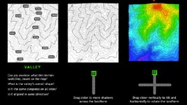
Topographic maps display three-dimensional landscapes on two-dimensional surfaces. The concise maps can offer a great deal of spatial information in minimal space. However, it is often difficult for people to interpret the features on a topographic map. This interactive activity adapted from Stephen Reynolds's "Visualizing Topography" Web site offers color-enhanced and three-dimensional visualizations to help interpret two-dimensional topographic maps.
Throughout history, various types of maps have evolved to display geographical information in different ways. Topographic maps were developed to show topography -- the three-dimensional features of a landscape. In a topographic map, the three-dimensional terrain, as viewed from above, is preserved in two-dimensions. The details of surface features, such as mountains and valleys, are recorded with clever use of lines. Topographic maps are useful in many fields, including agriculture, geology, paleontology, architecture, and the military. People even make use of topographic maps recreationally, such as when planning a mountain biking route or orienting themselves on a hiking trip.
Topographic maps illustrate surface features by utilizing both horizontal and vertical scales. All maps have a horizontal scale to represent distance. However, a topographic map also represents height with a vertical scale depicted by contour lines -- imaginary curved lines that connect points of equal elevation. If you were to follow a single contour line, you would remain at a single height above sea level. As a guide to reading a topographic map, there are darker lines every fourth or fifth contour line. These darker lines are called index contours and are marked with specific elevations so that the reader will have a reference to determine height.
The space between contour lines represents intervals of changes in height, so contour lines never cross or intersect. The steepness, or slope, of the terrain is displayed by the spacing of the contour lines. If a feature, such as a cliff, changes in height very quickly, the contour lines are very closely spaced. On the other hand, if the feature is fairly flat or has a gentle slope, the contour lines are widely spaced. Together, the number, spacing, and curve of contour lines depict both height and shape.
Because it is not always obvious how the two-dimensional contour lines are translated into three-dimensional features, it is often useful to create a topographic profile. Instead of producing an aerial view of the topography, a topographic profile uses contour lines to create a view from the side. By imagining the features from different angles, it is possible to look at a two-dimensional topographic map and be able to visualize the three-dimensional landscape that it represents.
 Loading Standards
 Teachers' Domain is proud to be a Pathways portal to the National Science Digital Library.
