
Source: NOVA: "Volcano's Deadly Warning"
National K -12 Subject:
Lesson Plans Using this Resource:
Not so long ago, people living near volcanoes had little that might help them to anticipate an eruption. A deep rumble, a puff of smoke, and ash might foreshadow a major volcanic event. Or a volcano might erupt with no warning at all. This interactive activity from NOVA Online illustrates some of the clues modern seismologists are using to better understand activity deep within a volcano, in hopes of improving their ability to predict eruptions.
Seismic Signals (HTML version) (Document)
The majority of earthquakes and volcanoes occur along the boundaries of tectonic plates. At these boundaries, slabs of oceanic or continental crust collide, slide alongside each other, or are torn apart. Their movement is driven by convection currents in molten material in Earth's mantle.
Plate boundaries are violent places. Slabs of solid rock that may be more than 30 kilometers (98 ft) thick are created or destroyed. Subduction zones, where oceanic crust is forced back into Earth's molten mantle, give rise to 80 percent of the world's earthquakes and volcanoes. The Circum-Pacific Belt or Ring of Fire, which stretches up the western coasts of South and North America, across the Aleutian Islands, and down the eastern coasts of Asia, is one such zone. The Mediterranean Belt, which divides Africa and Europe, is a smaller boundary zone, but it is extremely active, especially with respect to earthquakes.
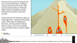
Earthquakes and volcanoes often occur independently of one another. In some cases, however, as this interactive activity describes, earthquake activity may foreshadow volcanic eruptions. Over the past decade or so, scientists have begun to read the seismic vibrations within volcanoes to try to better predict the timing and intensity of eruptions.
To measure earthquakes generated by volcanoes, scientists use a seismometer -- the same apparatus used to measure other types of earthquakes -- which records vibrations of Earth's crust. When rocks crack or slip past each other, or when magma applies pressure to the inside of a volcano's magma channel, the surrounding rock vibrates much the way a tuning fork vibrates when it is struck. Seismometers record both the intensity of the vibration, measured by the height of the line on the seismogram, as well as the vibration's frequency, measured by the distance between the peaks or valleys on the graph. Scientists use the information they collect from seismic events to gain a better understanding of volcanic activity inside a volcano, and if and when it might erupt.
 Loading Standards


 Print Background Essay