Source: NASA/Goddard Space Flight Center Scientific Visualization Studio
National K -12 Subject:
Lesson Plans Using this Resource:
Earth is a complex, evolving body characterized by ceaseless change. To understand Earth on a global scale means using a scientific approach to consider how Earth's component parts and their interactions have evolved, how they function, and how they may be expected to further evolve over time. This visualization adapted from NASA helps explain why understanding Earth as an integrated system of components and processes is essential to science education.
 Download, Share, and Remix
Understanding our planet as an integrated system of components and processes is a fundamental part of Earth and space science research. Just as the human body is composed of interrelated systems that control specific bodily functions, Earth's four principal components — the atmosphere (air), lithosphere (land), hydrosphere (water), and biosphere (life) — perform critical roles that, together, support and sustain life on the planet.
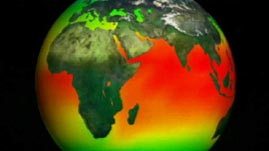
Nothing influences the subsystems that contribute to Earth's dynamic behavior more than heat. Heat comes from two sources: solar energy and radioactivity in the Earth's core. Because of the angle at which the Sun strikes Earth, Earth's surface is heated unevenly. This creates Earth's three major climate zones — tropical, temperate, and polar — which then influence what types of life flourish in different locations.
The uneven heating also controls weather systems. The heat absorbed by the oceans and carried by its currents is constantly being released into the atmosphere. This heat and moisture drive atmospheric circulation and set weather patterns in motion. The weather patterns then influence vegetation, as well as erosion and sediment transport.
The other heat source, deep within Earth's core, is responsible for plate tectonics, which gives the Earth its physical character: mountain ranges and valleys, ocean basins and lake beds, and islands and trenches. The heat from Earth's core generates convection cells within its mantle, which help drive plate activity.
Ever since the first photos were sent back from space, our view of Earth has changed. Remote sensing instruments, such as satellites, allow us to better understand the interrelationships between the different subsystems. For instance, recordings made by remote and Earth-based instruments show that significant surface warming has occurred over the past three decades. Knowing this, scientists are working to determine how this will affect — and already is affecting — the entire Earth system.
This resource has been selected by CLEAN for climate literacy education!
 Loading Standards


 Print Background Essay