Source: NASA/Goddard Space Flight Center

Mountain of Ice: If the Ice Melts
(Interactive)
National K -12 Subject:
Lesson Plans Using this Resource:
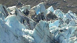
Scientific evidence strongly suggests that different regions on Earth do not respond equally to increased temperatures. Ice-covered regions appear to be particularly sensitive to even small changes in global temperature. This video segment adapted from NASA's Goddard Space Flight Center details how global warming may already be responsible for a significant reduction in glacial ice, which may in turn have significant consequences for the planet.
 Download, Share, and Remix
Ice covers 10 percent of Earth's land surface. One form of ice, found as glaciers, can form anywhere that snow and ice persist year-round. The two primary types of glaciers are valley glaciers, which are long, wedge-shaped masses that form in mountainous areas, and continental ice sheets, which are slightly dome-shaped and may cover millions of square kilometers. Non-glacial sea ice forms on the surface of seawater where it either persists year-round or melts and reforms seasonally.
Ice affects the entire Earth system in a variety of ways. In the ocean and at the land-sea boundary, ice prevents relatively warm ocean water from evaporating, transferring heat to the colder atmosphere, and thereby increasing global air temperature. Ice also reflects sunlight, thus preventing additional heat from being absorbed by water or land. However, the most significant role played by sea ice in the global climate system may be related to its role in ocean circulation. When sea ice forms, pure water crystallizes and leaves behind salt, thus increasing the salinity of the ocean. This cold, saline-enriched water is dense, and it sinks, creating a temperature and density gradient that moves ocean currents from the equator to the poles.
The well-documented retreat of the world's glaciers and diminution of sea ice is ominous. Data generated from satellites that monitor the formation of polar sea ice indicate that both coverage and thickness have decreased over the past three decades. Recent studies show that the world's highest glaciers (in the Himalayas) are receding at an average rate of 10 to 15 meters (33 to 49 feet) per year. If global warming accelerates melting, the predictability of water supplies for agriculture and other economic activities would be compromised. But even small changes in ice volume may have a significant impact on global climate and ocean circulation patterns, not to mention polar animal habitats.
Lastly, the breakup of the extensive ice shelves of the West Antarctic Ice Sheet, where sea temperature has risen by 4.5°C (8°F) in the past 50 years, could precipitate the collapse of the entire sheet. Should the West Sheet slide off the continent, the amount of water contained in it could raise global sea level by six meters (20 feet), flooding huge areas of low-lying coastlines.
 Loading Standards


 Print Background Essay