Source: NASA/Goddard Space Flight Center Scientific Visualization Studio
National K -12 Subject:
Lesson Plans Using this Resource:
Continents were once thought to be static — locked tight in their positions in Earth's crust. Similarities between distant coastlines, such as those on opposite sides of the Atlantic, were thought to be the work of a scientist's overactive imagination, or, if real, the result of erosion on a massive scale. This interactive activity adapted from NASA shows the position of Earth's continents on 11 massive tectonic plates and illustrates the motion of these plates relative to one another.
 Download, Share, and Remix
The first scientific theory to propose that Earth's continents had once occupied different positions than they do at present was Alfred Wegener's theory of continental drift. Despite the evidence Wegener presented, few experts at the time accepted that continents simply plowed through Earth's solid crust as they drifted around the globe, and the theory was widely dismissed.
In the late 1960s, scientists developed an alternative to continental drift: the theory of plate tectonics. Evidence gathered since Wegener's death in 1930 suggested that new crust was created at mid-ocean ridges and that older crust was destroyed at deep ocean trenches. This theory provided the mechanism for continental movement that Wegener's theory lacked. Earth's crust is not solid as once thought, but is made up of a dozen or so tectonic plates that move independently of one another.
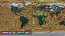
Because tectonic plates are not all moving in the same direction, the boundaries where they meet can be violent places. Today, geologists recognize three main types of plate boundaries. The first, called a divergent boundary, occurs most often at mid-oceanic ridges. Here, two plates move away from each other, creating a break, or rift, in Earth's crust. Magma from the mantle rises to fill the gap, thus creating new crust. Diverging plates do not all move at the same rate. The most rapid divergence — more than 17 cm (6.7 in) per year — occurs between the Pacific Plate and the Nazca Plate, far off the west coast of South America.
Boundaries where two plates move toward each other are called convergent boundaries. In general, if at least one of the plates along a convergent boundary is made up of relatively dense oceanic crust, the denser of the two plates subducts, or slides beneath the other. Volcanoes and earthquakes are common at such subduction zones. Not surprisingly, one of the most geologically active convergent boundaries separates the Philippine and North American plates from the Pacific plate — opposite the world's most active divergent boundaries. At other convergent boundaries, when both plates are made up of continental crust, one plate does not easily slide beneath the other and the continents buckle and fold to create mountain ranges, such as the Himalayas at the boundary between the Indian and Eurasian plates.
The last type of boundary is called a transform boundary. At these locations, plates slide roughly alongside each other in opposite directions. Tension builds when the plates become locked. This tension is ultimately released in the form of an earthquake. One of the most active transform boundaries separates the Indian and Arabian plates. Note that in this interactive resource, a fourth type of boundary - diffuse - describes a boundary where plates are moving in the same direction.
 Loading Standards


 Print Background Essay