Teachers' Domain - Digital Media for the Classroom and Professional Development
User: Preview

Source: The Bishop Museum Planetarium
This video, adapted from material provided by the ECHO partners, illustrates some of the methods that people from communities across the globe have used to navigate on the open ocean. European and American sailors relied on navigational instruments. Polynesian travelers used traditional techniques based on celestial navigation and on their observations of clouds, winds, birds, and other phenomena. And the Iñupiaq people of northern Alaska rely on their centuries-old knowledge of their environment to find their way while hunting and fishing.
For thousands of years, people have been traveling vast distances over land and sea to fulfill a variety of needs. They have ventured out in search of food, trade, exploration, and living space or land. Along the way, they have relied on the knowledge and skills of various navigation techniques to reach their destinations.
In the harsh Arctic climate of northern Alaska, the Iñupiaq people have obtained the majority of life's necessities by hunting and fishing. Such subsistence living is still in practice. Today, the Iñupiaq go onto the sea ice and into the ocean in boats to hunt seal, whale, and walrus, and travel inland to fish and hunt animals such as the caribou. Despite the difficult environment, they have been successful because of a deep knowledge of many aspects of their surroundings, including weather patterns. This knowledge has been cultivated from centuries of careful observation and passed down from one generation to the next. As they travel, Iñupiaq hunters can create a mental map that orients them to their surroundings. This ability comes from their knowledge about ice formations, the fact that snowdrifts are formed by winds that generally blow in a single direction, coastline features, the habits of migratory animals, and the location of inland lakes and rivers, as well as other elements of the environment and their related patterns. This type of navigation, which does not rely on instruments, is known as "wayfinding."
The Polynesians also used wayfinding techniques to navigate on ocean voyages. Through these methods, they were able to explore and colonize the far-flung islands of the Pacific Ocean. Since the Polynesian people lived on islands scattered over a huge area, they had to navigate with certainty over vast ocean distances with few physical landmarks. Thus, they developed systems for reading ocean currents and waves, observing the wind and weather, tracking the movement of the Sun, Moon, and stars, and recognizing birds, fish, plants, and atmospheric conditions that could help orient them along their route. Navigator priests — who were trained to have acute powers of observation and memory — were key in determining which course to follow.
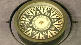
In Europe and North America, the desire to expand trade and develop commercial markets led to the creation of trade routes that spanned the globe. Systems relying on the stars, Sun, and Moon, compasses based on Earth's magnetic field, and reliable sea-going clocks were refined by the early 1800s such that mariners could travel reliably to places of which they had no previous knowledge — and then return home. This helped traders reap vast profits from trade networks in which the markets were thousands of miles from the sources of supply. A good example of this was the commercial whaling industry that stretched from Europe to Massachusetts to northern Alaska. With the development of new navigation tools, plus the 1802 publication of Nathaniel Bowditch's The New American Practical Navigator (also known as the "Sailor's Bible") — which included extensive instructions and charts for plotting the position of a ship anywhere in the world — navigation became a tool of international business.
Many cultures have developed navigation techniques that are appropriate for their needs and environment. Some cultures travel in small groups for subsistence hunting, others take entire families with them in search of a new home, and still others set off with a large crew to participate in cross-cultural commerce. In the end, navigation becomes a means for people to find their way around the world in order to get what they need to survive.
 Loading Standards
 Education through Cultural and Historical Organizations (ECHO) offers you resources on Teachers' Domain that strengthen knowledge of local culture and identity.
